Introduction
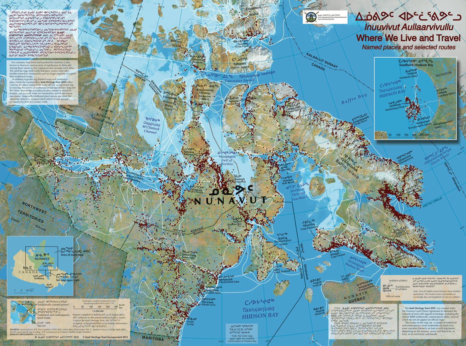
In the meantime, check out the map: Nunavut, Where we Live and Travel, to see the extent of traditionally-named places (dots) in our files at IHT (as of December 2014). As a gift to Nunavummiut, IHT delivered one of these maps to each post office box in Nunavut in June 2015.
The land has always been alive with names for all places of any significance to Inuit who have called this environment home for centuries. Until the middle of the 20th century, Inuit depended completely upon animals of the land for food, shelter, clothing and tools. To understand the land well was to survive. Naturally, Inuit communicated about places using names in their own language. Traditionally this knowledge was captured in a rich oral history. Two Goals
Inuit place names describe physical or cultural features in the landscape. Across the territory, examples and variations abound of Qikiqtarjuaq (big island) and Tasiujarjuaq (big lake) but so do names which describe fishing lakes and rivers and tidal pools “where the char go to digest their food”, walrus haul outs, spring camping areas (seal hunting), caribou hunting areas, hazardous areas (currents), as well as a multitude of other illustrative names. Long-standing Names One of the core principles for place naming in Canada according the Geographic Names Board of Canada is that “First priority shall be given to names with long-standing local usage by the general public.” Given that 85% of Nunavut’s population is Inuit and as many as 70% consider Inuktitut to be their first language, common sense dictates that traditional Inuit place names should appear on maps. New Names, Changing Names Since January 2006, 400 new names and name changes have been added to Canada’s official maps in Nunavut alone, in some cases replacing well known historical names. More than 1000 names are waiting their turn to be added to Canada’s maps. |
Viewing Syllabic Fonts
This site displays words in both roman and syllabic characters. Syllabic Font Test: If the two lines below closely resemble each other, your web browser is displaying syllabic characters correctly. ᐃᐱᑎᑭᒋᒥᓂ
Hints to properly display syllabics on your computer system
|